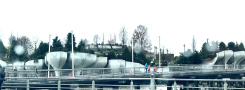
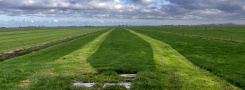
No, this is not a picture made on one of Jupiters moons. This is taken…
Did a very surveying-like thing today: walked a map of Tractie.
I meant to walk straight lines, detouring only when meeting with obstacles. As you can see, things didn’t work out this way – very wavy lines all through. Like the first crayon drawings the little girl made. Decided to see them as just that: the first tries of someone trying a new technique. Note: try a beach or some other place where my feet leave tracks.
Seeing my tracks from above changes my ‘internal recording’ of the walk in some way. May have to split my personality in two soon, so one can go walking and the other can – god like – watch me from above.


| « “Paradise haunts gardens, as it haunts mine” | <-- previous post | next post --> | Domkerk proposal: Was Malevich ever here? » |
|---|