Did a trial run with the exp 003 environment at IBB today. Entertaining! Pic is of…

 My research seems to be moving towards the question of ‘how do we use our bodies to explore the space around us’. At least that is the direction it seems to take right now.
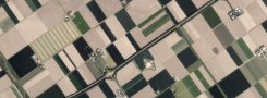
I came up with several artists that can be of interest to me as far as the subject of ‘exploring space’ goes & that I will research shortly. There are Francis Alys ‘London Walks’, pointed out to me by the lucky girl that lives next door and that has done a short stint at Artangel in Londen. There is artist Sophie Calle, who followed the tracks of a total stranger. And, first and foremost, Richard Long doing ‘a line made by walking’. Picture on the right is the original (now residing at the Tate), picture on the left is the remake that I did at the outdoors lab last friday. I made a color photograph, of course, and then photoshopped it to black-and-white so it resembles the original more closely.
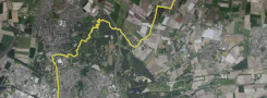
As I have more technology at my disposal than Richard Long had in 1967, I have a few other representations of my line as well. I recorded my walk with GPS. When I plot my track on Google Earth it looks like the picture below. One gets a totally different inpression, looking – god-like – from above. The actual grounds don’t resemble the Google Earth picture of it any more – nature took over, see my earlier posts.
 Comparing the two ways of representing my line reminded me of the ways men and women store spatial information, ways that are totally different. Men use direction (‘go to the north’) and distance (‘for about 200 metres’), which translates roughly to a Google Earth type of mental map. Woman go from node (‘start at the XXX building’) to node (‘then turn left at the next YYY shop’), which translates to a TomTom-like set of directions. Which is why men totally confuse woman when giving them directions, and the other way around. These different ways of storing and retrieving spatial information are reputed to date back to the time that men were hunters who went after a prey, and woman were gatherers going from interesting spot to interesting spot. I tend to distrust this kind of easy explanation, but the fact remains that the difference is there – I have tested it and it seems valid.
Anyway, using GPS gave me a set of coordinates for the starting point and the end point of my line. So now I can depict it in yet more different ways. I don’t mean ‘depict’ as in: needs pictures. I don’t need Google Earth or Google Maps. The easiest way of referring to my line is to give two sets of of coordinates, and my line can be re-traced exactly by anyone holding a GPS set: 
And I wil not need a gallery or museum to share my ‘line made by walking’ with the world. I simply use Google Maps:

Also, I became a member of Everytrail to share my line with – literally – everyone. Now I can Twitter about my ‘line made by walking’, or use Facebook to promote it, or use any of the myriad ways the Web offers to create connections. Neat, huh? The last image I will post sums all of the above up nicely: a USB stick containing all the representations of ‘a line made by walking’ on one little gadget.


| « War of Java – do you remember? | <-- previous post | next post --> | ‘Cutting reality out of a picture’ » |
|---|