We've started building an atelier space for me - how exiting is that? An old…
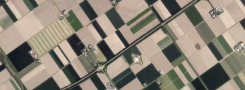

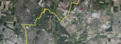
So the Dutch created Holland – which made me curious as to what part of the Netherlands would actually be lost to us if we didn’t beaver away at maintaining dykes and pumping water out of polders. A question Rijkswaterstaat – which is the government agency that is responsible for keeping the water out – was happy to answer.
One thing led to another, and today I composed a map that shows what part of the Netherlands would be lost to us if the water-wolf had had its way. Map shows: a pretty large part! Almost all of the Randstad area – which is the circle drawn through Amsterdam, Utrecht and Rotterdam, with den Haag, Schiphol and Haarlem thrown in – would be under the waves. Randstad is the economic motor of the Netherlands – so Amersfoort-at-sea doesn’t appeal to anyone……
As a next step I’m going to map out a bike route along the alternative coastline. I already have my sea smell, will make a sea soundtrack, and then my psycho-geographical tour can start.
Psychogeography was defined in 1955 by Guy Debord as “the study of the precise laws and specific effects of the geographical environment, consciously organized or not, on the emotions and behavior of individuals. (Wiki). Another definition is “a whole toy box full of playful, inventive strategies for exploring cities… just about anything that takes pedestrians off their predictable paths and jolts them into a new awareness of the urban landscape.” (Joseph Hart, “A New Way of Walking”).
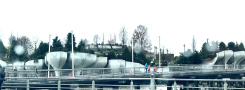
Curiously enough the Dutch word for a work of art (a ‘kunstwerk’) is also used to describe a work of civil engineering. To watch Rijkswaterstaat at work, I’m posting a video from YouTube:
[youtube]http://www.youtube.com/watch?v=RLVpj-9x44I[/youtube]
| « What If history | <-- previous post | next post --> | Spot On » |
|---|